Plotting the Sun
One important thing you can do to help your plants thrive is determine (a) how many hours of sunlight your garden site gets during the day, and (b) how this changes over the course of the growing season. As we said in the sun lesson, the sun’s daily path across the sky shifts higher or lower in the sky as the seasons change. To calculate this shift accurately you need to find your latitude, true south, the sun’s altitude, and its azimuth.
Your latitude is the distance (in degrees) your garden site is from the equator. You can find the latitude nearest you by referring to the map in this section or by using the latitude locator application listed here as well.
True south is found by using your compass to find magnetic north (and hence south) and correcting for magnetic declination. Magnetic north is the direction your compass needle points to, and it isn’t true north. True north will be a few degrees off, the exact number of degrees depending on where you are. You can use the same map you used to find your approximate latitude to find the declination line nearest you, and that will tell you how many degrees you need to adjust to get from magnetic north to true north. True south will be 180 degrees from true north.
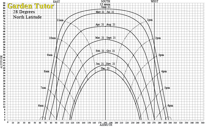
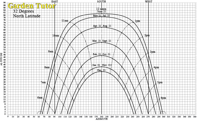
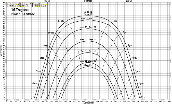
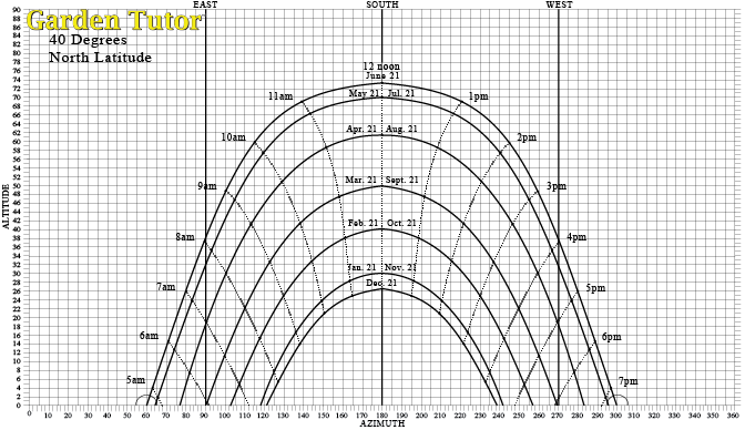
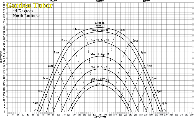
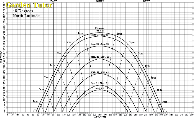
The sun’s altitude refers to how high it appears in the sky from the horizon. Its azimuth is the number of degrees east or west of due south the sun is at certain times of the day (this is known as solar time). In this section we provide pre-plotted charts of the sun’s altitude and azimuth for various latitudes throughout North America. Locate the chart nearest your latitude.
Once you have the appropriate sun plot, you are ready to determine the amount of sunlight your site receives:
- Bring your compass, handbook, tape measure, and a pencil to your garden site.
- Find magnetic north using the compass, then consult the magnetic declination map under. This will help you find the magnetic declination line nearest you. We have also provided a direct link to the NOAA.gov site which provides precise magnetic declination information based on your zip code. An example: if you are in Boston you would find that true north is approximately 14 degrees west of magnetic north. Rotate the compass clockwise until the N (north) on the dial of the compass is approximately 14 degrees east of the needle. Hold the compass at that point while looking where S (south) on the compass dial is pointing. Lay a stick on the ground pointing to true south, so you don’t forget.
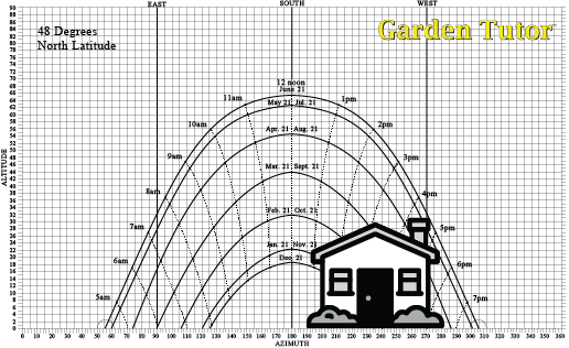
- Stand in your garden facing true south. Turn your head left and right, and locate any structures (trees, buildings, etc.) that will block the sun in your garden site throughout the growing season. To plot the impact of each structure you will need a device to measure altitude and the compass to find the azimuth. The device can be a pencil or stick which you can calibrate in degrees.
To calibrate your pencil or stick: lay it lengthwise along your measuring tape. Mark or notch the stick at 1/2″ intervals along the entire length of the stick. Each 1/2″ segment represents approximately one degree.
- To find the azimuth of each structure: Face true south
while holding the compass, which should also be lined up with true south. As you turn your head slowly to the left or right, stop when you come to the edge of the structure. Look at the compass to determine the number of degrees from true south you turned your head. That degree will be the object’s azimuth. - To find the altitude of each structure: Hold the calibrated stick vertically straight out in front of you. The stick should be 2 feet away from your face (you can use the measuring tape to verify this). Align the bottom of your stick with the base of the structure, and measure the height of the structure using your calibrated notches. (For our purposes we measure altitude in degrees.)
- You can then plot these dimensions on your chart and draw an outline of the structure(s). This will show you the times of the day the sun will be obstructed and when (or if) this will change over the growing season. Look at the times when the sun will be blocked. Make note of this and subtract that from the total number of hours of sunlight per day. You will then know precisely how much sunlight your site receives during the year.
Determining Magnetic Declination in your area
- Lookup your Latitude/Longitude first (right hand side of page)
- After generating you Latitude and Longitude they will load automatically in the Latitude and Longitude boxes on the left side of the page
- Select WMM (2014-2019)
- Enter the current date
- Choose HTML format
- Click on the “Calculate” button
Your result will come back with a map showing “True” North
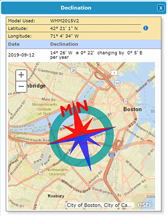
Note the declination figure in degrees and if it is West (W) or East (E) of north:
Date Declination
2019-09-12 14° 26′ W ± 0° 22′ changing by 0° 5′ E per year
Use the NOAA Magnetic Field Calculator:
Sun charts based on your Latitude (Northern)